The original Erie Canal was too small. By the 1830s, boats choked the shallow "Clinton's Ditch." So, the state started widening everything. They spent millions carving out the Enlarged Erie Canal to handle the explosive growth of mid-century American trade. In Albany County, this meant conquering the Cohoes Falls. The Mohawk River dropped seventy feet here. To bypass this obstacle, engineers designed a spectacular, tightly packed flight of locks. They stacked massive, hand-cut limestone blocks. Heavy, gray stone. Mules pulled barges loaded with Midwestern wheat and timber right past these lockkeepers' stations. This wasn't just local trade. It connected the Atlantic to the Great Lakes.
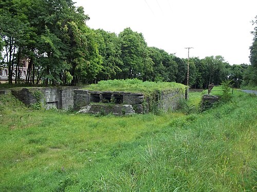
The NRHP listing is discontiguous for a reason. Modern roads paved over huge sections of the canal. But some incredible pieces survived. Look at the impressive remains of Lock 18 in Cohoes, where the double-chamber design is still entirely visible. This allowed two-way traffic, a necessity by the 1850s. The walls still show deep grooves. These came from heavy hemp towlines rubbing against the stone for decades. Walk further. You will stumble on dry ditches overgrown with sumac and weeds. In Watervliet, the old Side Cut locks once dumped boats directly into the Hudson River. Now, asphalt surrounds them. Yet, the masonry remains nearly perfect. It shows the incredible, millimeter-perfect precision of nineteenth-century stonemasons who worked without any modern lasers or power tools. Just hammers and sweat.
What Makes Enlarged Erie Canal Historic District (Discontiguous) Special: